
World Maps Get Africa’s Size Wrong: Why Fixing It Matters
.jpg)
The African Union has endorsed the #CorrectTheMap campaign, a global call for the adoption of world maps that portray countries and continents more accurately. The movement, launched by advocacy organizations including Africa No Filter and Speak Up Africa, urges the United Nations, the World Bank, educators, and textbook publishers to move away from the centuries-old Mercator projection. Already, the campaign has gained more than 4,500 signatures.
At stake is not just the technical design of a map, but how billions of people come to see Africa’s place in the world.
The Problem With Mercator
The Mercator projection, created by Flemish cartographer Gerardus Mercator in 1569, was originally designed to aid navigation during Europe’s age of exploration. Its ability to preserve straight compass lines made it invaluable to colonial powers seeking trade and conquest.
But Mercator is deeply flawed as a world map. It inflates the size of landmasses near the poles, such as Greenland, Canada, and Russia, while shrinking equatorial regions like Africa and South America. On a Mercator map, Greenland appears almost the same size as Africa, when in reality Africa is about 14 times larger. Africa is also three times bigger than Canada and 1.5 times larger than Russia, but you wouldn’t know it from looking at a typical school wall map.
This distortion is not just a cartographic quirk, it is a relic of colonial worldviews that have long diminished Africa’s geographic scale, cultural significance, and global role.
Equal Earth: A Fairer Alternative
To correct these distortions, the campaign calls for widespread adoption of the Equal Earth projection, developed in 2018 by cartographers Bojan Šavrič, Bernhard Jenny, and Tom Patterson. Unlike Mercator, Equal Earth is an equal-area projection, meaning it represents all continents in their true relative sizes while maintaining familiar shapes and visual balance.
Cartographers have long experimented with alternatives. The Gall–Peters projection, popularized in the 1970s, was one of the first to address issues of size, but its stretched and distorted shapes limited its appeal. Equal Earth improves on this by offering accuracy and visual clarity, making it suitable for both classrooms and policy use.
Why It Matters
Maps are not neutral. They are instruments of power and storytelling. Lines, colors, and symbols communicate meaning, influencing how people—from schoolchildren to world leaders, understand the world.
As cartographer Tom Patterson has noted: “Maps shape how we remember and understand the world.” A distorted map not only misinforms but also reinforces existing inequalities.
This distortion has real consequences. Former U.S. President Donald Trump’s reported interest in buying Greenland, for instance, was partly shaped by maps that depict the island as far larger than it truly is. In reality, Africa dwarfs Greenland, but Mercator’s imagery inflates perceptions of Greenland’s strategic importance while minimizing Africa’s.
Selma Malika Haddadi, Deputy Chair of the African Union Commission, put it bluntly: “These distorted maps marginalize Africa, influencing perceptions in education, media, and global policy.”
A Colonial Legacy
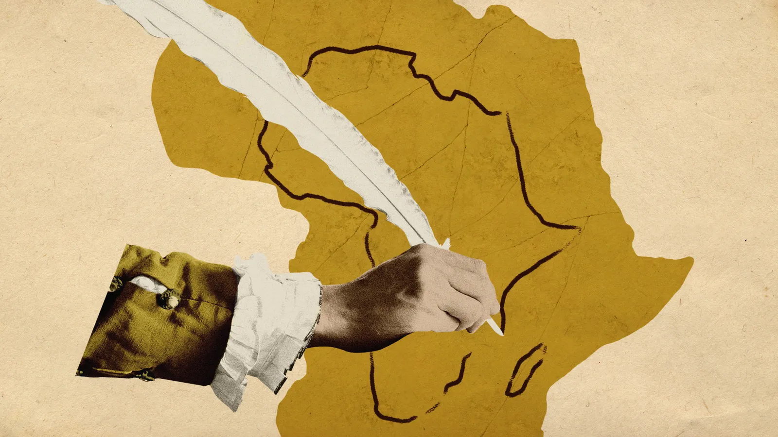
For Africa, the debate is especially charged. Cartography was a tool of domination during colonial times. European powers used maps not just to explore but to justify conquest, drawing borders at conferences like the infamous Berlin Conference of 1885, where Africa was carved up without African participation.
Mapmakers filled European atlases with routes, resources, and blank spaces to be “developed,” while ignoring the sophisticated mapping traditions of African societies. The Mercator projection, still dominant today, is part of this legacy of minimizing Africa’s presence in the global imagination.
The Challenges of Change
Shifting the world’s default map is not simple.
No single authority governs map production, meaning adoption requires consensus across governments, schools, publishers, and technology firms.
Mental images of the world are ingrained at an early age, making any change disorienting. Boston Public Schools’ switch to the Gall–Peters projection in 2017, for example, sparked resistance from parents and educators.
Even when institutions adopt new maps, uptake can be slow. The World Bank, for instance, has embraced Equal Earth and Winkel Tripel projections in some of its outputs, but others still default to Mercator. Google Maps displays the globe view on desktops, yet Mercator remains embedded in mobile applications.
Still, momentum is growing. The African Union’s endorsement gives the campaign political weight, adding to calls from educators, activists, and policymakers around the world.
Beyond Cartography: Restoring Dignity
The push to correct the map is not just about cartographic accuracy. It is about restoring dignity, agency, and visibility to Africa and other marginalized regions.
As Fara Ndiaye of Speak Up Africa explains:
“When generations learn from a distorted map, they develop a biased view of Africa’s role in the world… For non-Africans, a shrunken representation minimizes its demographic, economic and strategic significance.”
In this sense, Equal Earth is more than a map. It is a symbol of equity, a challenge to centuries of cartographic marginalization, and a step toward reframing how the world sees Africa.
Looking Ahead
The path forward requires:
Curriculum reform so schoolchildren learn from maps that reflect the true size of Africa and the Global South.
Policy advocacy to encourage international organizations, from the UN to the World Bank, to standardize equal-area projections.
Media adoption, ensuring journalists, publishers, and broadcasters use maps that tell a more accurate story.
Public engagement, so people begin to question the maps they see and understand their impact.
As The Guardian observed in a recent editorial, adopting a fairer projection is a symbolic yet powerful act: “Drawn true to its scale and promise, Africa cannot be ignored.”
Correcting the world map will not erase centuries of distorted representation or instantly rebalance global power. But it is an essential step. The Equal Earth projection is more than a technical fix, it is a political, cultural, and educational opportunity to help the world see Africa, and itself, more honestly.
Shifting the map projection may be difficult. But continuing with Mercator’s colonial distortions is costlier. In the words of the #CorrectTheMap campaign: “It’s time the world sees Africa as it really is.”
Reporting by: Jack Swab, Assistant Professor, Department of Geography & Sustainability, University of Tennessee Derek H. Alderman, Chancellor’s Professor of Geography, University of Tennessee